 |
 |
 |
 |
 |
 |
 |
 |
 |
 |
 |
 |
 |
 |
 |
 |
 |
|
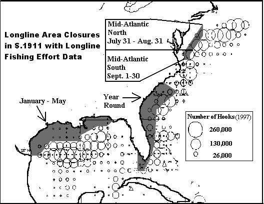
AREAS FISHED BY U.S. LONGLINERS
(Source:� NMFS)
In Relation to
Boundaries of the Longline Area Closures Proposed by Members of Congress as the Atlantic Highly Migratory Species Conservation Act
(S. 1911 and H.R. 4773)
Map Developed by the National Coalition for Marine Conservation |
|
|
|
 |
|
|
|
It can be easily seen that the areas fished most heavily by U.S. longliners and thus the areas most important to them (as represented by the circles) are just outside (seaward of) the boundaries of the closure areas proposed in S. 1911 (the "Breaux Bill") for the Gulf of Mexico and Southeast U.S. coast.� Therefore, these closures will have little conservation value.� The mid-Atlantic closure area added by Congressman Saxton's proposed bill (H.R. 4773) includes about half of the area fished heavily by longliners along the Gulf Stream between Cape Hatteras and the eastern tip of Georges Bank.� For maps showing the effects on each billfish species, follow the links below. |
|
|
|
 |
|
|
|
GO TO:
Maps Showing Effects of Closures on:
White Marlin
Blue Marlin
Sailfish
Closures - Overview
Severity of Decline of Atlantic Species
Overview
List of All Pages on this Website
Home |
|
|
|
|
|
 |
|
|
|
|
|
Chambers and Associates
9814 Kensington Parkway
Kensington, Maryland 20895-3425
(T) (301) 949-7778���� (F) (301) 949-3003 |
|
|
|
|
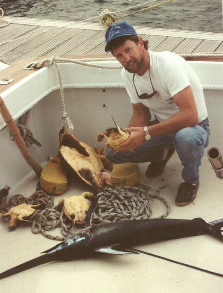
Above, juvenile swordfish and threatened loggerhead turtles.� Both are vulnerable to longline gear as are billfish and, in fact, anything with a mouth large enough to swallow or be foul-hooked on the 2-inch (offset) hooks predominantly used by longliners.������ (Photo, G. Wouters) |
|
|
|
|


